 02 8319 2266 from Australia
 416-628-3473 from Canada
 04 889 4515 from New Zealand
 646-757-1102 from the USA


 Jotunheimen Tour

The Jotunheimen Tour: A guide to the trek
 Walking guides - see all our background pages
Introduction
In 2018 we were thrilled to introduce our first Norwegian trekking area, the Jotunheimen. We apply our explorations to this exciting, wild, area with the hope of showing it to our Alpine trekkers. It is a step harder than the majority of our Alpine walking, with rocky terrain that requires sure footing. The glacial lakes, wide mountain view and friendly Norwegian hospitality make it an ideal hike for experienced trekkers.
Bare Facts
Length 6 walking days, 7 nights for our main trip (we also offer an extended Tour, which has 8 walking days and 9 nights)
Total distance 90km or 56 miles
Typical day 16km (10 miles), 700m ascent
Highest altitude 2,465m
Grade Black4
Best bits
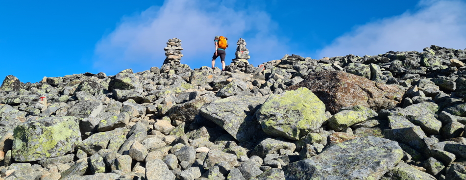
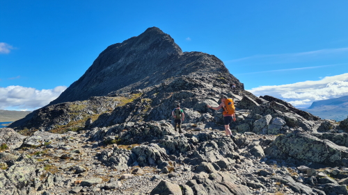
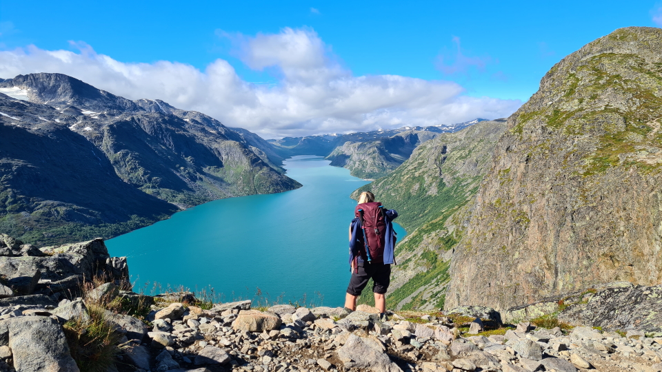
The Besseggen ridge on stage 6 of the Tour is a real highlight! One of Norway's most well-known hikes, the rocky path climbs between two glacial lakes and offers dramatic views in all directions. Some use of hands is needed over the ridge, and the ascent and descent is steep.
In good weather, another highlight is the ascent of snow-covered Glittertind, Norway's second highest peak. The extensive views accross the Jotunheimen from the summit are unrivalled.

Trips
Alpine Exploratory offers the following holidays based on our Jotunheimen research:
Jotunheimen Tour
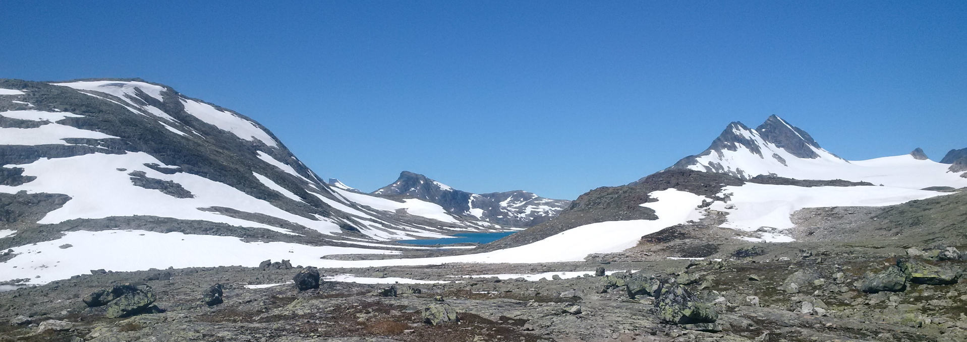
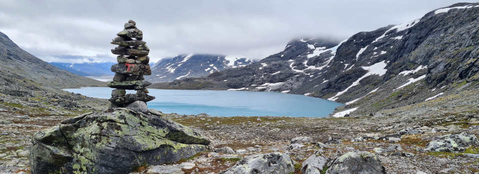
 Typical rocky boulder fields encountered on the Jotunheimen Tour

The Walking
What's it like underfoot?
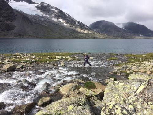
The landscape of the Jotunheimen Tour is quite rounded with wide valleys. Based on statistics alone, the days may not look overly hard, with elevation gain and loss in the hundreds of metres rather than thousands, and most days comfortably under 20km. It's the terrain that provides the challenge in the Jotunheimen. In fact this means that the days are quite balanced, a shorter day but trickier underfoot! The harsh snow-melt cycle means boulderfields are common, and snow patches are also found which may seem a little daunting at first but are easily crossed in walking boots. The trekking months of July and August are of course when much of the snow melt is in full swing, so the valleys run with small streams which are comfortably crossed with care. Well-made bridges are there for the larger crossings.
Is it technically difficult?
The Jotunheimen Tour is first and foremost a walk, however it has some technical elements. Firstly, rocky terrain on all stages makes for slow going. Foot placement is key and concentration is required. This is particularly the case on the first 3 stages of our main tour (and especially the stage to Fondsbu on the extended tour).
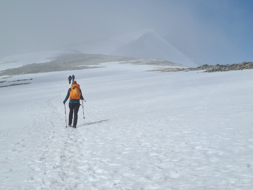
Stage 2 includes a summit of Glittertind, Norway's second highest summit (an alternative route can be taken to miss this), and there is an option to add a stage which summits the highest mountain Galdhøpiggen. If included, these 2 stages include snow crossings, even in high summer. The stages are within the walker's realm but at the highest end.
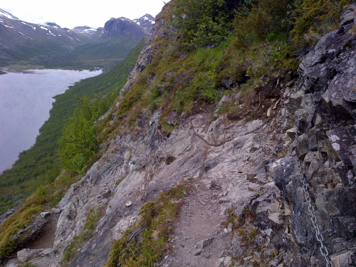
Secions of very steep ascents and descents on some sections can also be relatively technical, in particular on the final 2 stages along Lake Gjende, and on the descent from Glittertind. Some scrambling is needed, as well as a good head for heights. Chains aid the ascent of the Bukkelægret on stage 5, and with one section of descent on stage 6. This element is similar to the trickier sections of steep terrain encountered in the Alps.
Is the route obvious?
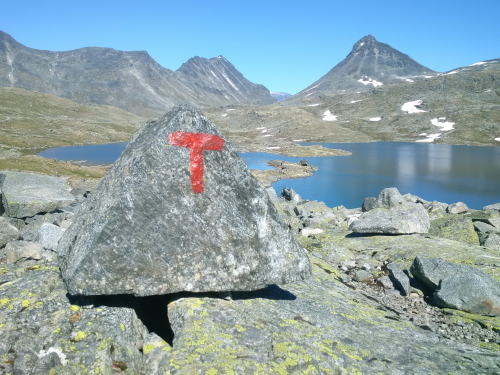
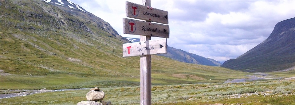
Our route follows waymarked trails in the Jotunheimen National Park, and are all marked by red painted T's on the rocks. The rocky terrain means there often isn't a traditional path, but the painted T's lead you in the right direction. On the snowy tops, twigs and sometimes way markers show the way.
It is essential for all parties on the Jotunheimen Tour to have at least one competent navigator with a map and compass, for those situations where the clouds have closed in. The best maps for the route unfortunately still have mistakes. Our routecards, notes and maps give you all you need to complete the trek under your own steam.
Is it for me?
The stages on the Jotunheimen Tour don't include the sorts of long, steep and relentless ascents and descents that are found in the Alps. The challenge is instead in the unrelenting rocky terrain encountered. The trip will suit sure-footed trekkers with mountain experience who are happy to walk for up to 9 hours in a day.
Navigation experience is also key, as the route passes through isolated and wild terrain. Once you lose sight of the morning's hut, you often won't see another dwelling or cultivated land until you arrive at your destination for the night, the waymarkers and friendly greetings of 'got tur' from those passing in the other direction being the only signs of civilisation. In a sense, hiking in the Jotunheimen is refreshingly unlike routes in the Alps which typically pass through pastoral farmland, villages, and huts catering to the lunch trade, but on the flipside, this means that self-reliance is key.
What will the weather be like?
You should be prepared for all weathers in the Jotunheimen. Summers are generally warm but similar to Scotland in that rain could fall at any time. The park shares its latitude with Canada's Yukon or mid-Russia, which might help put it into context. The benefit, of course, is the long hours of sunlight! In July and August the sun has well and truly risen by 5am and will set at about 10pm. What a great luxury not to be concerned with daylight hours! Dinner is normally served in two sittings at around 6.30pm and 8pm thus a relaxing day is certainly possible. Wind chill can make it feel colder than it is and it is possible for summer snow to fall at any time. A warm jacket is recommended.
When to go?
Our season runs from mid July to the end of August. This short season is in part dictated by the buses, which only run during these peak months.
How long to hike for?
The DNT's superb network of paths and our logistics mean that trips of anything between 3-8 days are an excellent option. The full 8 stage trip takes in a circuit that encompasses almost the entire breadth and height of the park. You'll find that the stages contrast greatly, as the landscape in the Johunheimen is swift to change from lush valley to barren boulderfields to lakeside paths.
Shorter trips work well and can be aided by the ferry which runs between Gjendesheim, Memurubu, and Gjendebu. The path from Leirvassbu to Gjendebu is a handy link between the northern and southern sides of the walk which makes shorter circuits work really well.

Norwegian Mountain Culture
Of course Norway is well known for its Winter sports but in Summer, as the snow melts, Norwegian families return year after year to walking in the outdoors. As you'll experience, trekking and the outdoors form an absolute part of the Norwegian cultural soul.
The Norwegian approach is orderly with a time-honoured reverence to preserving their natural spaces and maintaining the national parks for the next generation. You will meet Norwegian walkers of all ages with their families, even meeting three generations together is common. With so few foreign walkers it's easy to feel warmly adopted into this lifestyle.

Norwegian huts
The hut system is possibly our favourite out of any nation and really typifies the Norwegian experience. A stay in one is a glimpse into the small things which form the nation's hiking culture; for example, in hot or cold weather, it is expected that you will be trekking with a thermos flask, as is the Norwegian way, so in the evening all guests line up their flasks, labeled with name and hot beverage of choice and miraculously come breakfast they are full and ready to provide sustenance for a day on the hills. Food in the huts is chiefly Norwegian, with all that can be grown in Norway if not the local region. Hearty mountain food is found for dinner, as you might expect!
A touch we appreciate is that lunch is made at the breakfast table from the excellent breakfast spread. Expect Norwegian cheeses, cured reindeer sausages, robust home-made seeded bread, a whole section of the buffet dedicated to pickled fish and vegetables as well as more conventional choices. Meals are communal and an excellent opportunity to dine and chat with local trekkers (who will undoubtedly have impeccable English). You'll have to tear yourself away to bed early or risk a spirited night of beer and cards.
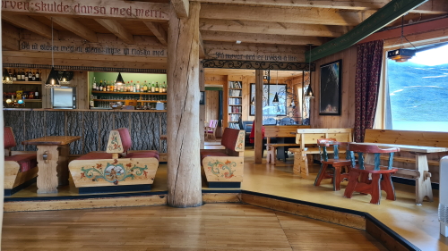
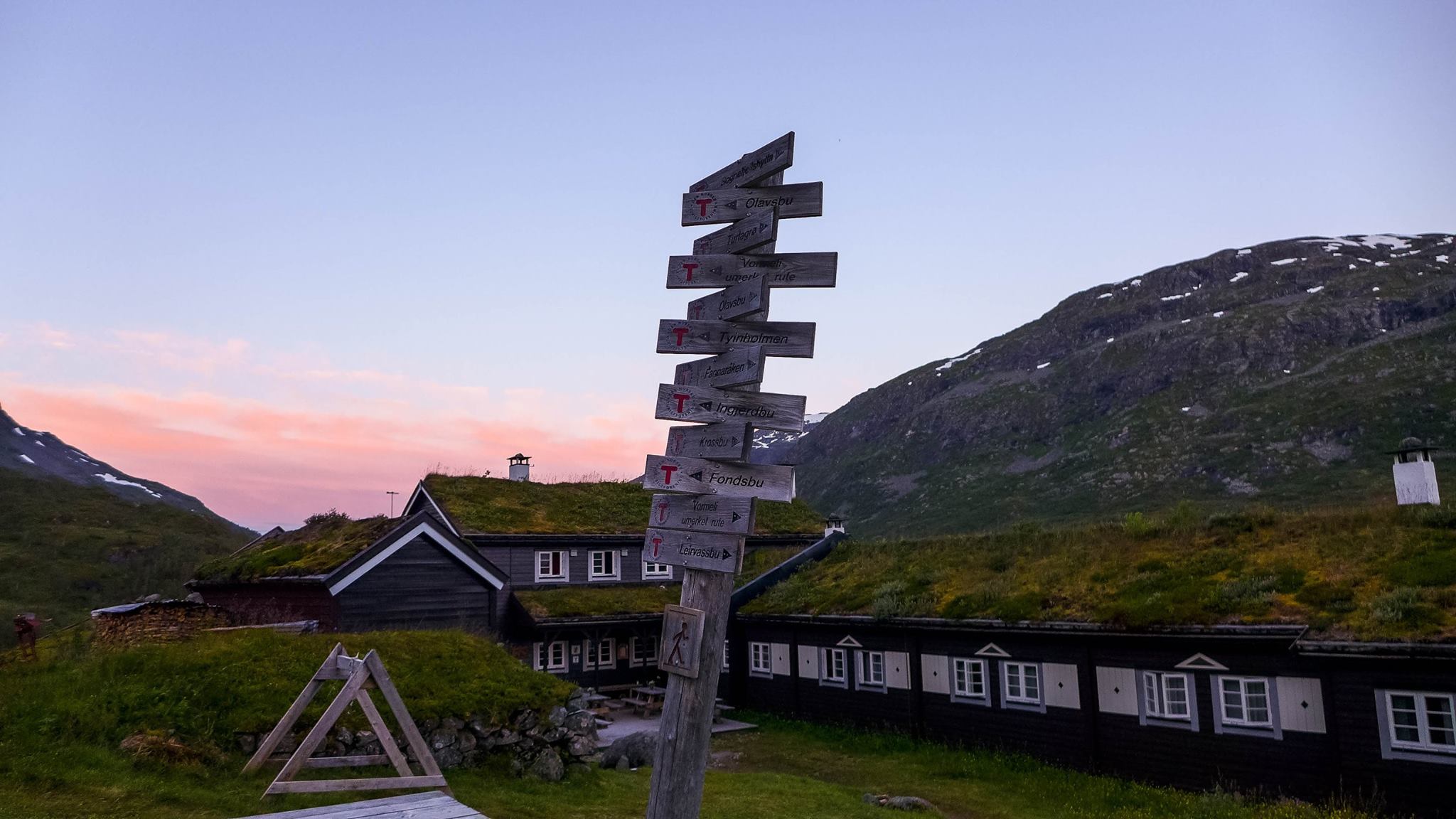
The huts are normally family-run, often having spent generations in the same family. You'll notice the feel of the huts reflects the character of the owners. Some huts are independent, however many are a part of the DNT, Norway's national trekking association, which is tasked with the duty of maintaining the walking routes and signage. You'll become very familiar with the DNT logo by the time you leave. The red 'T' flash painted on rocks will become a welcome reminder that you haven't strayed off course! Anyone on one of our trips of 5 nights or more will become a DNT member for the year which can be handy if you'll be doing any more walking in Norway before or after the Jotunheimen, as it gives you discounts towards your lodging.
The DNT
The DNT, Den Norske Turistforening, is the Norwegian trekking and travel association. The DNT runs many mountain huts and maintains information offices in Norwegian towns. We include the year's DNT membership with all of our Norway treks.
 The DNT's website
Hut facilities
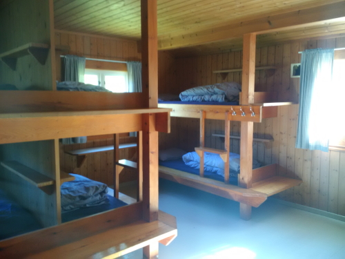
The huts on the trip have the option for either private rooms or dormitory places. We can book either, whichever you prefer. The dorms are generally wooden bunkrooms of a high standard. The egalitarian nature of Norwegian society and the welcoming character of mountain culture means that no one is ever turned away from the hut. There's a chance you may find it a lot busier than expected, which we hope you'll take as all part of the experience!
The routine of the hut life is similar to the Alps; walkers will begin to arrive between about 4 to 7 pm. The showers run hot, not limited by the supplies of the Alpine solar heaters! It's a nice chance to relax with a drink of local craft beer until dinner. You'll find homely spaces to enjoy into the evening. Norwegians enjoy a leisurely start to the day; after all, there's all the daylight you could desire. Breakfast is eaten about 8am with a view to setting off around 9.30. Rather civilised!
Cities and Travel
The starting point of the walk is easily reached from the cities of Bergen and Oslo. Our notes contain all the details to make the journey with confidence by bus or train but to give you an idea, it's about 5 hours' by coach from Oslo, and about 7 by train from Bergen. The buses and trains will likely be filled with Norwegians of all ages escaping the city on their way to adventure in the hills.
Both Oslo and Bergen make superb stops before or after the trek. We've visited fairly frequently both through the pursuit of research so we've amassed some suggestions we hope you'll enjoy in our notes.
The accommodation on the trip is mainly hut-based starting at the cosy and grande Gjendesheim hut which sits on the road-head where you'll arrive from Bergen or Oslo.
City breaks after trekking
Our Jotunheimen holidays come with notes on the following cities, in your info pack:
 Bergen in Norway
Oslo in Norway
Trondheim in Norway
Stavanger in Norway
City breaks after hiking in Scandinavia
The Route: Stage by Stage
Stage 1
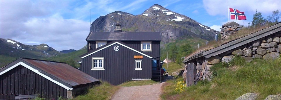
Today we strike out North, leaving Gjendesheim behind as we head into the more remote landscape of the Jotunheimen. Pass the ends of the Bessvatnet and Russvatnet lakes on fairly level ground (look out for reindeers in the section of open ground) before heading up and beginning the ascent proper. Our aim is the rocky Hestlægerhøe col. From the top the Glitterheim hut is visible, though a long way off! The gentle descent must be taken steadily as large rocks lie underfoot; an introduction to the sort of terrain that will be found frequently in days to come. Glitterheim is a delightful hut with a cosy living room to enjoy after the long day.
Stage 2
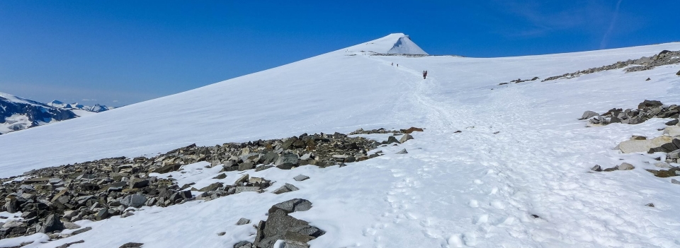
This is a superb day, a summit of Norway's second highest mountain (by 4 metres), Glittertind. Glittertind had been the highest until its glaciated peak melted too much and it was dethroned by its close neighbour, Galdhøpiggen. The rocky ascent becomes increasingly snow covered until the snowfield proper is reached. After about two hours of ascent, the rounded summit is reached and spectacular views await! The descent to Spiterstulen hut is rocky but rewarding with some steep but easy scrambling required. A long walk out passing dry rocky river beds ends this challenging, but rewarding day.
The path is safe in fair weather. It's well traveled and perfectly possible in walking boots, as the glacier has a good covering of snow. We also suggest a gentler lower route in case which we recomend in poor weather.
Stage 3
Today is is a welcome break after yesterday's efforts. A walk through vast sweeping valleys with snowmelt running off the steep mountains lining either side. Some careful rockhopping will be required today as we cross quite a few streams, with water at about ankle height. After a long and very gentle descent the valley opens out as the path follows the rocky boulderfield lining a series of lakes. Leirvassbu sits on the far shore of the final lake. It is a true gastronomic hut with an excellent three course dinner!
Stage 4
A short, stiff climb leads to a pass and the revelation of the spectacular long valley ahead with a line of glacial lakes. Pass the turning to Olavsbu and an isolated hut on a promontory in the lake. The route drops beside a huge waterfall and the steady descent to Gjendebu begins. One of the more rustic huts and sits in a super location at the far end of the Gjende lake.
Stage 5
On the final 2 days we hike the length of Gjende, over high rocky paths. A super finale to the trek! The mid point is Memurubu our hut for the night. Today's route crosses a plateau guarded on each end by steep rocky paths. It's especially steep on the way up from the shore of lake Gjende and helped by chains. The middle section of the day gives high and wild views to the North. Arrive at Memurubu in a grassy setting by the shore.
Stage 6
The last day to Gjendesheim is real highlight of the trip! Despite being one of the iconic images of Norwegian tourism, the Besseggen Ridge is a quieter route than you might be led to believe. It truly is beautiful although there are tricky sections of terrain and some scrambling is required. Much of the day is rocky underfoot, some without a well defined path but always well marked with protruding cairns. A stunning lower level lake-side path can also be taken for an easier option.
Optional extra days for a longer trip
Lairvassbu to Skogadalsboen
This day follows the valley onward on a good track past a network of streams and pools that cover a lush valley floor. If the other days were a bit barren, this is filled with flowers and plant life making the most of the brief Summer months. The route passes a dam - a rare sign of human engineering! - before descending gently through meadowland and amongst birch trees. Skogadalsboen is a magical hut, completely off-grid and one of the only huts that can only receive deliveries by helicopter. It is a real retreat from life (and phone signal!)
Skogadalsboen to Fondsbu
A day through the wilder western half of the park, the path ascends from the valley onto a barren height plateau where a rocky valley leads to the beautiful pair of mountain lakes, Urdalsvatnet and Kvitevatnet before descending down the course of the valley to Fondsbu. Rocky boulderfields underfoot make this one of the hardest days on the route.
Fondsbu to Gjende
A well rounded day in the Jotunheimen on solid paths (a relief after the prvious stage!). The route begins along lake Bygdin before ascentding to reach a plateau with wide views. A wide rocky valley is followed to reach the lakeside and the Gjende hut.
Galdhopiggen ascent from Spiterstulen
Galdhopiggen (2,469m) is the highest point in Norway and indeed the Nordic region. This optional day's walk is an out-and-back ascent from Spiterstulen. It is within the walker's realm but crosses extensive snow patches near the summit, even in high summer. These are marked by twigs and sometimes waymarks. Depending on conditions, there could be snow-covered ridges and boulders too. It is a popular path and an achievable summit for strong walkers. The summit view is exceptional, of snow-filled corries with turquoise tarns. A small manned hut at the summit serves coffee, snacks and souvenirs. Galdhopiggen is something of a pilgrimage for Norwegians and you will see many more walkers coming from the Juvashytta glacier route to the North, the two routes meeting at the summit.
Hike the Jotunheimen Tour with Alpine Exploratory
Alpine Exploratory offers two self-guided options - long or short - as well as private guided trips. We're also pleased to book shorter or longer sub-sections of the route according to your available dates. Please contact us to discuss options
Our self-guided holidays give you what you need to complete the route under your own steam. We book your accommodation in a mix of huts and hotels and we give you our detailed routecards, the local maps, and lots of notes. Importantly we will advise on the ideal schedule and accommodation to suit your approach to the Jotunheim.
Our guided trip is similar but gives you the benefit of an Alpine Exploratory leader to show the way.
Keep up with us on Facebook, Instagram, and our Blog for photos and updates from our own travels and clients' trips.


  Jotunheimen Tour enquiry form
|


 Alpine Exploratory
 +44 (0)131 214 1144
