 02 8319 2266 from Australia
 416-628-3473 from Canada
 04 889 4515 from New Zealand
 646-757-1102 from the USA


 Via Alpina

The Via Alpina: A guide to the trek
 Walking guides - see all our background pages
Introduction
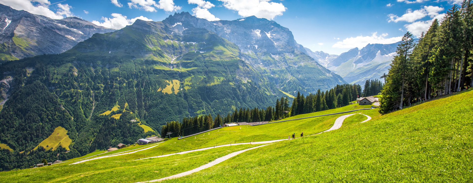
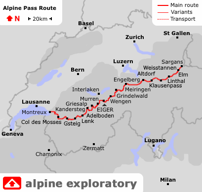
The Via Alpina (formerley the Alpine Pass Route) crosses Switzerland from East to West, from Sargans to Montreux. The whole trek is well over 300km and takes between two and three weeks.
We cover the whole route in three weeks, as well as the Central section, also the highest, from Engelberg to Kandersteg on our Bernese Oberland trip. This would suit walkers looking for one week on the most spectacular Via Alpina stages. To complement the Bernese Oberland week we also offer East and West weeks in their own right.
The theme, as with any trek in this part of Switzerland, is the crossing of passes (cols) to walk from one valley to the next.
The lie of the land
The highest pass on the Via Alpina is the Hohturli (2,778m) between Griesalp and Kandersteg. In practice most trekkers will make the short detour from the Hohturli to the Blüemlisalphütte (2,834m) just above, in effect making this the high point of the trek. Three other cols are above 2,500m on the whole Via Alpina (two of them in the Central week) while most cols are in the range 2,200m to 2,500m.
The Via Alpina travels past glaciated peaks such as the Wildstrubel (Kandersteg to Adelboden) and the Eiger, Monch and Jungfrau. The trail itself stays solidly on trekking terrain. At times this trek is at the upper end of the difficulty range for accomplished trekkers, needing confident foot placement and good balance. Most days comprise the spectrum of Alpine landscape, rising through woods to meadows above, topped by a col crossing either grassy or rocky.
Best bits
The last two stages of the Bernese Oberland section cross two notable passes, the two highest on the whole Via Alpina: The Sefinafurgga (2,612m) and the Hohturli (2,778m). These are classic Alpine walking days, achievements in their own right. Views at these two cols open up to the high peaks above neighbouring valleys. Especially at the Hohturli the scene is fabulous with glacial features.
For a stage full of interest, more in a human way, Grindelwald to Wengen crosses the Kleine Scheidegg with its Eiger-bound tourist trade. We walk up to that col under the North Face of the Eiger.
While East and West weeks are less spectacular, they involve steady crossings of cols from the grassy to the mildly rocky and, as a finale to the whole three weeks, the ascent of the Rochers de Nayes. This peak looks down over Montreux, our final night, and offers a mountain railway descent as well as walking.
Trips
Alpine Exploratory offers the following holidays based on our Via Alpina research:
Via Alpina Switzerland
Via Alpina: Bernese Oberland
Our self-guided holidays give you what you need to complete the route under your own steam. We book your accommodation in a mix of huts and hotels and we give you our detailed routecards, the local maps, and lots of notes.
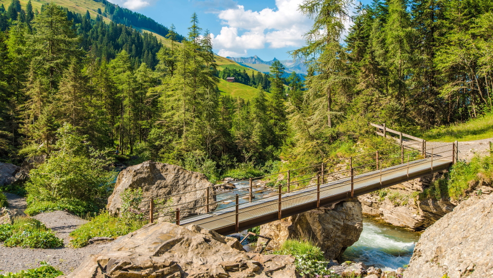
 Looking to Grindelwald on stage 4 on our Bernese Oberland trip

Is it for me?
The Via Alpina is likely to satisfy stronger trekkers who like a good day out in the hills. You'll know you've had one! In the week from Engelberg to Kandersteg, for example, the difficulty builds up right to the last day. The crossing of the Hohturli is notable for its wooden steps on the approach and the scree paths on the way down.
Not all of the passes are like this, however, and by judicious choice it's possible to walk 3 or 4 consecutuve days over the lower, grassier passes such as the Grosse Scheidegg (1,962m).
The route is relatively even in terms of daily distances and difficulty, given the range of areas and terrain encountered. This gives a pleasing rhythm. The Swiss set-up caters extremely well for trekking in this way.

Can I manage it?
The hardest parts of the route (in terrain terms) are the ascents to the Sefinafurgga and the Hohturli, the two highest Via Alpina passes. Both passes have ascents and descents over at times loose shale and scree. The wooden steps (up and down the Sefinafurgga and up to the Hohturli) give solid walking but the angles are at times daunting and need a good head for heights. In bad weather the experience is needed to judge whether to cross the pass or to go around by train and bus.
In terms of distance, the route is not unduly hard each day; the lifestyle of trekking point to point is one that is quickly settled into, we find, and that gives a relaxing pace of life. Your day is reassuringly governed by the main event, crossing to the next valley.
What's it like underfoot?
Forest paths in the valleys are straightforward enough, rising to the open meadow where narrow hard-pack (or muddy) paths cross grassland. Above, we venture into the high hills and good balance is needed on loose rocky paths and steps. In descent from the Hohturli to the Oechinensee there is hard walking on rocky paths, at one point along the crest of a lateral moraine. Textbook geography! Some drops to the side are substantial and good footing is essential.
Are the routes obvious?
The paths in the Swiss Alps are aided by frequent waymarking. This means a mix of white-red-white paint flashes on rocks and trees, or occasionally yellow diamonds painted on rocks and trees. Signposts are present at most of the main junctions, yellow-enammelled metal, with estimated times given.
The presence of a waymark of course only tells the walker that they are on a path - not which path it is! Another key point is that there is no official Via Alpina given on signposts. Instead the walker must follow for the day's destination. Often this is given as the village across the pass (e.g. Grindelwald) but until the pass it might just be the pass itself (e.g. Grosse Scheidegg) at which point signs start to point to further destinations.
Despite the good waymarking and signposting, it is essential for all parties in the Swiss Alps to have at least one competent navigator with a map and compass, for those situations where the route is not marked at a turning or where the clouds have closed in. Our routecards, notes and maps give you all you need to complete the trek under your own steam.
During each summer season, snow falls on typically two or three or more occasions. It tends to go away equally quickly and tends not to be deep at the altitude of the Via Alpina, but for the time that it remains it can make navigation quite challenging. Under a cover of snow, ground features are hidden and reliance on map and compass skills is key.
Is the walking technically difficult?
Our Via Alpina is a walk, not containing any climbs or via ferrata routes. There is no glacier walking and no rock climbing.
There are however some sections where the path crosses rocky and steep ground including steep scree slopes, plus sections with metal cables as handrails over normal Alpine walking terrain. Some stages cross open, unforgiving terrain without easy escape routes: full days of mountain walking calling for self-reliance especially in wet weather with bad visibility.
Unseasonal weather
The typical summer's day in the Alps brings hot sun, perhaps with occasional rain or afternoon storms, but in any case paths clear of snow. However, fresh snowfalls occur each summer on a handful of occasions. Most often, these leave a coating of an inch or two on higher passes only, and they disappear in a day or two. However, sometimes the snow stays for longer periods and is deeper. While the Via Alpina should be approached as a summer Alpine trek, with Summer snow unlikely, it is wise to know that snow can fall even in summer.

When to go?
Our Via Alpina season runs from mid-July to mid-September.
This short season is imposed by the weather: the chance of late-Spring snow patches remaining into the middle of July across the higher passes, and the chance of the weather deteriorating into late September. Because we can't predict the weather for the coming summer, we have to set these dates in advance.
Re-routing between Lenk and Rochers de Naye
In 2020, 2021 and 2022 the Via Alpina around Gstaad and Col des Mosses was fluctuating among some different routes on the ground; that is, local Swiss authorities (Club Alpin Suisse) were moving the Via Alpina from Lauenen, Gsteig and Col des Mosses above Les Diablerets, towards the North to Gstaad, l'Etivaz and Rossiniere. We like some of these new routes but not others! Specifically we are glad to give in our Routecards the routes via Gstaad and l'Etivaz, but not as much via Rossiniere. During 2022 we completed our full recces of the new routes, and we are advising on nights at Gstaad instead of Gsteig, and at Chateau d'Oex instead of Col des Mosses. This makes the walking better, and also the nights! This is all on the Western week.
On the Eastern week we are able to advise in our Routecard VAS1 on the optional Vaduz-Sargans day, before our route starts in Sargans. We do not recommend adding this day as a matter of course, but it is an option for those with the time and energy.
Every year, our short season is imposed by the weather: the chance of late-Spring snow patches remaining into the middle of July across the higher passes, and the chance of the weather deteriorating into late September. Because we can't predict the weather for the coming summer, we have to set these dates in advance.
Where to stay
Switzerland really is the neat, organised country of popular imagination, with very few exceptions. If anything doesn't work then it comes as a surprise. This carries over to the Swiss hotels and huts. Many of the towns or villages on the Via Alpina are Winter resorts also catering to a big Summer trade (walking, mountain biking, general outdoorsy holidays) and have several good hotels.
Food in Switzerland is a curiosity. Breakfast buffets are generally well-provided, and we seek the ones with imagination and as much fresh food as possible. Bread is the staple (unlike Italian breakfasts!) with bircher muesli and fresh fruit common. Coffee aplenty, of course. To evening meals, sometimes the range of dishes is more basic, with a meat and vegetables theme.
It is possible to stay in some mountain huts (refuges) while doing the Via Alpina. The Swiss huts (whether privately owned, or Swiss Alpine Club) follow a common Alpine pattern, built and run to cater for big numbers of trekkers in a practical and comfortable way. Dormitories are common, sometimes private rooms as well. (We will advise on the sleeping arrangements according to your particular schedule.) Food is typically bought from the counter during the day, then in the evening a half-board system operates with a set menu.


The Via Alpina in context
The Via Alpina compared to treks in the UK
Trekking in the UK tends to be about distances more than elevation gain, making comparisons difficult. Supposing you were to trek in the English Lake District by asending the higher peaks (Scafell Pike, Helvellyn) daily for a week, with 1,000m of ascent and descent over sometimes very rocky and loose terrain, this would more closely approximate the Via Alpina than does the Coast to Coast or West Highland Way. However, a good idea is given by the Coast to Coast stage from Grasmere to Patterdale if the Helvellyn ascent option is taken.
The Via Alpina compared to the TMB and the Walker's Haute Route
These other treks bear a lot of comparison, being series of valley crossings across cols of varying difficulty. The Sefinafurgga and Hohturli cols on the VAS, as the two hardest, take the difficulty level beyond that of the TMB up to that of the Walker's Haute Route. Perhaps the settings are a little less wild and demanding than the hardest of the Haute Route. Otherwise, the mix of distances and grassier cols is akin to the TMB, especially as we reach the more undulating and cross-country Western end of the Via Alpina. Overall, the theme of crossing cols is more consistent on the VAS. It really is a crossing of passes from one side of Switzerland to the other.
Comparing our 5 big Alpine treks
The Haute Route is substantially the toughest, suitable only for trekkers with particularly solid experience, balance and fitness.
The Via Alpina includes three rocky cols that approach the Haute Route's level of challenge, though the route as a whole is more forgiving. The same applies to the Adlerweg but in its case one col (the Eppzirlerscharte) stands above the rest as very difficult, and it can be skipped by descending and taking the train. The Adlerweg is notable for some long days on wide tracks.
The AV1 is more consistent in its difficulty but is especially demanding of good balance, with steep, rocky and wild situations calling for mountain experience.
The TMB is a superb all-rounder that mixes tough, solid mountain days with gentler ones, allowing trekkers to sample the harder terrain as at the Fenetre d'Arpette (a variant, shared with the Haute Route) while not requiring any extremes.
It's worth noting that each trek has different possible schedules, governing the physical difficulty, and on many days different variants affect the terrain difficulty.
Below we compare the stats of our 5 big trips:

Three weeks of Alpine trekking across the width of Switzerland

Distance: About 349km or 219 miles
typically done over 18 stages
Ascent: About 19,960m (65,485ft)
Highest point: Just over 2,800m (9,180ft) and the route crosses three passes above 2,300m
Terrain: Good mountain paths, rocky and steep cols, grassy cols, tracks and country lanes
Accommodation: Good hotels and no huts (but can be added)
Season: Mid-July to mid-September
Three weeks of Alpine trekking in the Tyrol from St. Johann to St. Anton
Distance: About 387km or 242 miles
typically done over 19 stages
Ascent: About 14,400m (47,240ft)
Highest point: Just over 2,250m (7,380ft) and the route crosses a number of cols above 2,000m
Terrain: Good mountain paths, forest tracks, some rockier and looser sections, tracks and country lanes
Accommodation: Hotels and huts in a varied mix
Season: Early July to mid-September
A week and a half of Alpine trekking from Dobbiaco to Belluno

Distance: About 120km or 75 miles
typically done over 10 stages
Ascent: About 6,650m (22,000ft)
Highest point: Just over 2,750m (9,000ft) and the route spends much time over 2,000m
Terrain: Good mountain paths, some rockier and looser sections, tracks and country lanes
Accommodation: Mostly mountain huts, plus hotels at start and finish
Season: Mid-July to mid-September
Two weeks of Alpine trekking in a circuit from the Chamonix valley

Distance: About 180km or 110 miles
typically done over 11 stages
Ascent: About 10,700m (35,000ft)
Highest point: Just over 2,500m (8,200ft) and the route crosses several passes around 2,500m
Terrain: Good mountain paths, rockier and looser sections, cables and ladders, tracks and country lanes
Accommodation: Hotels, huts and auberges in a varied mix
Season: Early July to mid-September
Two weeks of Alpine trekking from Chamonix to Zermatt

Distance: About 200km or 125 miles
typically done over 14 stages
Ascent: About 12,900m (42,300ft)
Highest point: Just under 3,000m (9,800ft) and the route crosses several passes over 2,900m
Terrain: Good mountain paths, rocky and loose sections, wild remote cols, cables/ladders, tracks and lanes
Accommodation: Hotels, huts and auberges in a varied mix
Season: Mid-July to mid-September
Hike the Via Alpina with Alpine Exploratory
Alpine Exploratory offers the full Via Alpina trip and the main central section (Bernese Oberland). We're also pleased to book shorter or longer sub-sections, according to your available dates and preference for harder or easier passes. It can work well to split the full trip over 3 seperate week long holidays. Please contact us to discuss options.
Via Alpina
Via Alpina: Bernese Oberland
Our self-guided holidays give you what you need to complete the route under your own steam. We book your accommodation in a mix of huts and hotels and we give you our detailed routecards, the local maps, and lots of notes. We also offer the option to make your trip guided. Our guided trips are similar but give you the benefit of an Alpine Exploratory leader to show the way.
Please ask us any time for more details. Please feel free to describe your walking experience and preferences, and we'll suggest which trek you might enjoy most.
Keep up with us on Facebook, Instagram, and our Blog for photos and updates from our own travels and clients' trips.


  Via Alpina enquiry form
|


 Alpine Exploratory
 +44 (0)131 214 1144
