 02 8319 2266 from Australia
 416-628-3473 from Canada
 04 889 4515 from New Zealand
 646-757-1102 from the USA


 Walker's Haute Route

You are here: Alpine Exploratory
> Walking guides
> The Walker's Haute Route: Walking guide
The Walker's Haute Route: Walking guide
Bare facts
The Walker's Haute Route is a walking trail through the French and Swiss Alps, for 221km (137 miles) from Chamonix in the West to Zermatt in the East.
The highest point reached by the standard route is 2,987m (9,799ft) and the height gain on the route is around 15,200m (49,867ft).
Trekkers typically take 14 days to complete the hike, give or take a day or two.
Best bits
Our clients say...
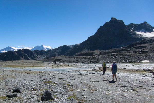
We ask our Haute Route clients which stages they enjoyed most. Many love the thrilling suspension bridge on the Europaweg as they head into Zermatt, but also popular are the exciting and challenging stages between Cabane du Mont Fort and Arolla across the high rocky passes as well as the approach to Cabane de Moiry and its breathtaking glacier.
With good weather the last stage allows the perfect view down into Zermatt, and up to the Matterhorn, as you traverse the rocky hillsides high above the Mattertal.

Trips
Alpine Exploratory offers the following holidays based on our Walker's Haute Route research:
 Walker's Haute Route
Walker's Haute Route West
Walker's Haute Route East
Walker's Haute Route (Guided)
 Lac des Dixs from the Col de Roux

Names - a brief note
The Walker's Haute Route is the proper title, in order to distinguish this trek from the original mountaineering route from Chamonix to Zermatt which is best referred to as the Classic Haute Route. This Classic route is the ski or mountaineering route across glaciers, taking a line generally to the South of the Walker's Haute Route. The French term Haute Route simply means High Route, as indeed it is!
Is it for me?
The joy of trekking
There is great satisfaction in completing stages of a long-distance trek, even more so when it's a famous one like the Haute Route. There might be times when the climb seems too much effort, and when you encounter bad weather; at such times the goal keeps you going. Equally there should be days when you feel all-powerful, tackling the mountain trails as if they were paths in the park!
One of the best feelings on trek can be nearing the end of a stage, once you're well into the walk, knowing that you've ticked off another leg of the quest. At such points you've also got an evening in a new village to look forward to. Travelling in a self-sufficient manner through the culturally and linguistically diverse terrain of the Haute Route, this all makes for a thoroughly enjoyable and satisfying holiday.

Can I manage it?
The Haute Route is the most challenging trip in our schedules. It is suitable for the fittest mountain walkers who are comfortable walking between 6h and 8h 30m or more per day along continuously rocky and steep terrain on a long-distance trail. It will greatly help your enjoyment of the trek to arrive fit at the start, used to walks of similar distance, terrain and height gain to those that you are about to face.
The toughest stages are the 2 continuous stages between Cabane Mont Fort and Arolla. This involves climbing over 4 separate cols in a very vast and remote environment. The paths are a mixture of boulder fields, rocky paths, and steep scree, as well as a mud-packed path for sections of the trail. Another tough section is walking along the Europaweg between the Europahütte and Taschalphütte (this is closed for the 2025 season). The stage with the most ascent is on the way to Cabane de Moiry from La Sage which includes a 1,690m ascent to reach the hut and it's impressive glacier. The difficulty of the Haute Route lies in the continuously difficult terrain and the steepness of the ascents and descents around the cols.
For those wary of walking the Haute Route in one go, there are many towns and villages along the route suitable for rest days. We can add one rest day in Arolla, for example, or two rest days in Champex and Zinal. Please just let us know your thoughts.
Of course, the Haute Route can also be tackled over two holidays each fitting into a week. We offer both the West and the East halves and we enjoy booking these as excellent trips in their own right.
What's it like underfoot?
Underfoot you will experience a variety of tracks and trails on the Haute Route. Standardly the mountainous sections run on single-track paths that can be rocky in places, sometimes with steps but mostly just the bare earth. Tracks are also common - perhaps gravel forest roads, ski pistes, or rough tracks for vehicles over agricultural land. There are some sections of country lanes. Unusually even for an Alpine trek at this level, some of the mountain passes are particularly steep, loose and rocky, calling for good experience and steady balance. An alternative to one of these steep cols is a series of ladders, almost vertical.
Is the route obvious?
The Haute Route has sections that are particularly difficult to navigate, if the visibility is poor. This is particularly the case for the stage between Cabane Mont Fort and Cabane Prafleuri. Other sections are well way-marked and signposted. It is crucial to note that there is no set 'Haute Route' trail; instead the route follows pre-existing paths and tracks. It's crucial therefore to pick the correct ones!
During each summer season, snow falls on typically two or three or more occasions. It tends to go away equally quickly and tends not to be deep at the altitude of the Haute Route, but for the time it remains it can make navigation even more challenging. Under a cover of snow, ground features are hidden and reliance on map and compass skills is key.
It is essential for all parties on the Haute Route to have at least one competent navigator with a map and compass, for those situations where the route is not marked at a turning or where the clouds have closed in. The best maps for the route unfortunately still have mistakes, which comes as an additional hazard. Our routecards, notes and maps give you all you need to complete the trek under your own steam.
Is it technically difficult?
The Walker's Haute Route is first and foremost a walk, but it is essential to note that it is at the very top end of difficulty in terms of Alpine trekking. The difficulty of the terrain is often underestimated. There is no glacier walking, no Via Ferrata and no rock climbing. There are however some sections where the path crosses exceptionally rocky and steep ground. In particular the Col de Riedmatten en-route to Arolla is very steep and loose with chains in place to help you with the ascent. Please note that the Pas de Chevres ladders have now been closed permenantly on the Haute Route due to severe rockfall. Additionally, our main route finishes with the two-day Europaweg into Zermatt which presents any trekker with loose hillsides, boulder fields, and navigational challenges. Each year there are diversions in place due to rockfall. Please contact us and we'll be happy to describe these spots in more detail. Your joining notes contain detailed information about likely hazards on the trail.
Unseasonal weather
The typical summer's day in the Alps brings hot sun, perhaps with occasional rain or afternoon storms, but in any case paths that are clear of snow. However, fresh snowfalls occur each summer on a handful of occasions. Most often, these leave a coating of an inch or two on higher passes only, and they disappear in a day or two. However, sometimes the snow stays for longer periods and is deeper. While the Haute Route should be approached as a summer Alpine trek, with snow quite unlikely, it is wise to know that snow can fall even in summer.
We show this photo in order to be clear what an unseasonally wintry day can mean for the terrain underfoot. This is the Haute Route near Cabane de Prafleuri, in the morning, setting out on the stage to Arolla.

When to go?
Our Walker's Haute Route season runs from late July to the middle of September. This short season is imposed by the weather: the chance of late-Spring snow patches remaining into early July across the higher passes, and the chance of the weather deteriorating into late September. Because we can't predict the weather for the coming summer, we have to set these dates in advance. The Haute Route is a particularly high route and this is the reason for the later start than our other Alpine treks.
Where to stay
The Haute Route's accommodation is a major attraction of the route. At various points there are choices of mountain huts, luxurious hotels, more modest hotels, and auberges with a mix of rooms and dormitories.
Most accommodation is family-run, even in the larger places such as Zinal. Our Haute Route clients often volunteer how much they enjoy the variety of the places we book for them; we aim to give a true experience of the Alps and of the Haute Route. In Zermatt we book a superbly well-run yet not extravagant hotel, for a memorable finish.
Research
Alpine Exploratory's research on the Walker's Haute Route is led by one of our People. Typically, one or two of our team look over the Haute Route each July, walking a selection of (or all of the) stages in order to keep us up to date and to assess the snow level. These visits result in our Season Update which we send to clients each July.
Recces
City breaks after trekking
Our Walker's Haute Route holidays come with notes on the following cities, in your info pack:
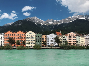
 Geneva in Switzerland
Zurich in Switzerland
Bern in Switzerland
City breaks after hiking in the Alps

The route
Here's a brief guide to the places and experiences on the Haute Route, on our normal 14-stage schedule.
Stage One
Start in Chamonix at about 1,000m (3,281ft). On this first stage we describe two routes. Our main route takes to the hillside across from Mont Blanc, with a cable car possible, to reach the beautiful mountain lake Lac Blanc at 2,352m (7,717ft). The route then descends steeply to Argentière which is the night's destination. The alternative route sticks to the valley, being a steady and picturesque climb to Argentiere through woods and meadows. The high alternative gives an appreciation of Chamonix before the Haute Route sets off into Switzerland; the low route gets there more directly but is still a hard walk.

Stage Two
From Argentière the Haute Route crosses the Col de Balme at 2,131m (6,991ft). This is a gentle pass, grassy slopes rising up on the French side in what is a busy ski area in winter. Dropping down the far side, the path is steeper but this stage remains a moderate introduction to the Haute Route's theme of crossing cols. We drop into the hamlet of Trient for the first night in Switzerland.
Stage Three
The next stage offers another choice of routes. Our routecards describe the main route via the alpage of Bovine at 1,987m (6,519m) as well as the challenging variant over the famous Fenêtre d'Arpette at 2,665m (8,743ft). Arrive in Champex, a small Swiss resort next to its emerald-green lake.

Stage Four
Today's aim is the working village of le Chable in the Val des Bagnes. This fourth stage comes as a contrast to the mountain routes so far. It's largely in the valley, first descending through woods and fields to Sembrancher where the railway from Martigny is met, and then crossing fields in the valley floor as far as le Chable. This is a chance to recharge before three hard stages all involving much ascent!
Stage Five
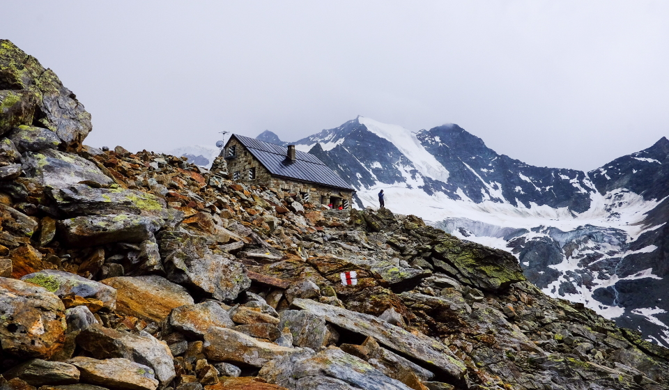
Setting off from le Chable, settle in for 1,700m (5,577ft) of ascent to the day's destination, Cabane du Mont Fort at 2,457m (8,061ft). A steady rhythm sees the hillside chapels, wooded glades, tracks and paths pass quickly enough, all the time gaining height above the valley. In clear weather, Mont Blanc comes into sight. This is a stage of great transition, from everyday working rural Switzerland to the edge of the high mountains. There are also cable cars in place to skip some of the ascent today.
Stage Six
After a night at the Cabane in its grand setting rimmed by jagged rock peaks, it's time to leave for one of the Haute Route's toughest stages. Two cols are available to reach the high basin above Lac de Louvie... Col de la Chaux or Col Termin. Chaux is wild and rocky, Termin is more amenable, and both have a particular set of scenic views. This first col out of the way, the route continues to two more: Col de la Louvie and then Col de Prafleuri at 2,987m (9,800ft) which is the highest point reached on the Walker's Haute Route. A final drop to Cabane de Prafleuri completes this remote and rocky stage. Knees will be glad of the rest after the almost entirely pathless and often bouldery miles. We cannot recommend hiking this stage in bad weather, and instead recommend taking the escape routes described in your routecards.
Stage Seven
Possibly the second hardest stage of the Haute Route comes today. This is the walk to Arolla. First a swift climb over Col des Roux to enter the grand basin of the Dix reservoir, an impressive setting. The route continues beyond the waters, skirting the Glacier de Cheilon. Now comes the steady climb up to the base of the Col de Riedmatten, followed by the steep ascent over the col with its loose rocks and steep angle. After this section the roll down to Arolla is a gentle and views onto the glaciers open up. The village is tiny but has all we need, at the head of Val d'Herens.
Stage Eight
Three hard stages marking the crux of the Haute Route are over, so today is a welcome contrast. The walk down to Les Hauderes then up to La Sage is solidly in or just above the valley, on decent tracks and paths. It is also a modest distance, giving time to restock and relax. La Sage is a village typical of the Valais, our region here in the Swiss Alps, with heavy stone flags for roofing and with agriculture carrying on all around. We recommend walking past the aptly named "Lac Bleu" en-route.
Stage Nine
Once more into the mountains! Our normal route takes us over Col du Tsate at 2,868m (9,409ft), to then descend to the Lac de Moiry basin before a second distinct climb to Cabane de Moiry. The day has a lot of ascent at 1690m in total but the reward of staying overnight next to the Glacier de Moiry makes it all worth it.
Stage Ten
From Cabane de Moiry the Haute Route retraces its steps a little, traverses high above Lac de Moiry, then climbs to Col de Sorebois. This col at 2,835m (9,301ft) is a grassy and easy one compared to many others on the route. The views onto the bright blue lakes get better and better as you ascend. Once at the top, a long descent takes us down to the pleasant village of Zinal in one branch of Val d'Anniviers.

Stage Eleven
The next valley reached is the Turtmantal. We are into German-speaking Switzerland at the rocky ridge dividing Val d'Anniviers and the Turtmantal. From Zinal the route climbs to the Forcletta at 2,874m (9,429ft), a rocky pass to new Alpine landscapes. High-mountain views abound from this point before rolling downhill to the small village of Gruben.
Stage Twelve
Today's is the last stage with the Haute Route's classic up-then-down pattern. From Gruben we climb steadily to the rocky but wide Augstbordpass at 2,893m (9,492ft). In descent, we enter the Mattertal... the valley shared with the Matterhorn, no less. That celebrated peak remains hidden by high mountain walls. After the high alp of Jungen with its barns and houses, the route zig-zags down to St Niklaus in the industrial part of the valley floor. At last in the final valley, we are near our goal!
Stage Thirteen
Today we start the two-day finale into Zermatt, the famous Europaweg trail. This section of the Europaweg was partially destroyed by a landslip in 2018, and reopened in 2022 after extensive rerouting. The new trail descends from Gasenried to Herbriggen in the valley, before a steep rocky ascent, with handrails in places, to rejoin the old high trail shortly before the Europahutte. Purists may wish to hike the new Europaweg in full, but in order to avoid climbing steeply up from the valley to Gasenried only to descend to the valley again, we generally recommend walking along the valley as far as Herbriggen before joining the Europaweg here. Once up and on it, the route crosses in and out of seemingly improbably rocky combes on the steep hillside. The Matterhorn comes into sight at the head of the valley. Rounding a spur we reach the wooden Europahutte at 2,265m (7,431ft) and our home for the night. (As an alternative to this difficult 2-day finish, we also offer the easier 1-day valley route from St Niklaus to Zermatt.)
Stage Fourteen
The Europaweg continues, today's initial sections retaining the characteristic challenge, but these challenges giving way steadily to easier walking as Zermatt is reached. Tunnels and avalanche-protection walls are interesting features. In 2025, there were diversions via Tasch in place between the Europahutte and Taschalphutte due to rockfall. Finally walking high above Zermatt, the full height difference with the Matterhorn's summit can be seen. A last descent past barns and huts at Findeln brings us into town. The bustle of Zermatt brings no problems of adjustment, such is the magical nature of this town.

The Walker's Haute Route in context
The Haute Route compared to treks in the UK
Compared to most treks in the UK, the Haute Route has lower daily distances but the terrain presents many more challenges and the trail has much more ascent. The Coast to Coast route in England, for example, has an average stage length that is twice as long, as per our normal schedule, but most stages do not climb as much. Of course, the altitude is higher throughout on the Haute Route, as it is on most Alpine treks. The high valleys in the Swiss Valais are around 1,500m, but the highest point in England is under 1,000m!
The Haute Route compared to the TMB and the Via Alpina
The Walker's Haute Route is by some margin the hardest of our five big Alpine treks. Compared to the TMB, the Haute Route climbs to higher passes, tackles looser and rockier terrain, and spends more time in wild locations where walking experience is key. Not everyone who has done the TMB will enjoy the Haute Route; it would be preferable to find the TMB well within one's capacity as opposed to getting through it. The Fenetre d'Arpette, shared by the TMB and Haute Route, is a good guide to the consistent level of the Haute Route.
Compared to the Via Alpina, the Haute Route has many more instances of those hardest cols with a narrow gap on the ridge and steep loose slopes on both sides. Such mountainous situations come consistently along the Haute Route.
Comparing our 6 big Alpine treks
The Haute Route is substantially the toughest, suitable only for trekkers with particularly solid experience, balance and fitness.
The Via Alpina includes three rocky cols that approach the Haute Route's level of challenge, though the route as a whole is more forgiving. The same applies to the Adlerweg but in its case one col (the Eppzirlerscharte) stands above the rest as very difficult, and it can be skipped by descending and taking the train. The Adlerweg is notable for some long days on wide tracks.
The AV1 is more consistent in its difficulty but is especially demanding of good balance, with steep, rocky and wild situations calling for mountain experience.
The TMB is a superb all-rounder that mixes tough, solid mountain days with gentler ones, allowing trekkers to sample the harder terrain as at the Fenetre d'Arpette (a variant, shared with the Haute Route) while not requiring any extremes.
It's worth noting that each trek has different possible schedules, governing the physical difficulty, and on many days different variants affect the terrain difficulty.
Below we compare the stats of our 6 big trips:

France and Switzerland
Two weeks of Alpine trekking from Chamonix to Zermatt
Two weeks of Alpine trekking from Chamonix to Zermatt

Distance: About 200km or 125 miles
typically done over 14 stages
Ascent: About 12,900m (42,300ft)
Highest point: Just under 3,000m (9,800ft) and the route crosses several passes over 2,900m
Terrain: Good mountain paths, rocky and loose sections, wild remote cols, cables/ladders, tracks and lanes
Accommodation: Hotels, huts and auberges in a varied mix
Season: Mid-July to mid-September
Italy
A week and a half of Alpine trekking from Dobbiaco to Belluno
A week and a half of Alpine trekking from Dobbiaco to Belluno

Distance: About 120km or 75 miles
typically done over 10 stages
Ascent: About 6,650m (22,000ft)
Highest point: Just over 2,750m (9,000ft) and the route spends much time over 2,000m
Terrain: Good mountain paths, some rockier and looser sections, tracks and country lanes
Accommodation: Mostly mountain huts, plus hotels at start and finish
Season: Mid-July to mid-September
Italy
Two weeks of Alpine trekking from Bolzano to San Candido
Two weeks of Alpine trekking from Bolzano to San Candido
Distance: About 134km or 83 miles
typically done over 11 stages
Ascent: About 8,800m (28,870ft)
Highest point: Antersas at 2,907m (9,530ft) near Rifugio Boè, and the route spends much time over 2,000m
Terrain: Good mountain paths, rockier and looser sections, scree and boulders, and tracks
Accommodation: Hut and hotels almost in sequence
Season: Mid-July to mid-September
France, Italy and Switzerland
Two weeks of Alpine trekking in a circuit from the Chamonix valley
Two weeks of Alpine trekking in a circuit from the Chamonix valley

Distance: About 180km or 110 miles
typically done over 11 stages
Ascent: About 10,700m (35,000ft)
Highest point: Just over 2,500m (8,200ft) and the route crosses several passes around 2,500m
Terrain: Good mountain paths, rockier and looser sections, cables and ladders, tracks and country lanes
Accommodation: Hotels, huts and auberges in a varied mix
Season: Early July to mid-September
Austria
Three weeks of Alpine trekking in the Tyrol from St. Johann to St. Anton
Three weeks of Alpine trekking in the Tyrol from St. Johann to St. Anton
Distance: About 387km or 242 miles
typically done over 19 stages
Ascent: About 14,400m (47,240ft)
Highest point: Just over 2,250m (7,380ft) and the route crosses a number of cols above 2,000m
Terrain: Good mountain paths, forest tracks, some rockier and looser sections, tracks and country lanes
Accommodation: Hotels and huts in a varied mix
Season: Early July to mid-September
Switzerland
Three weeks of Alpine trekking across the width of Switzerland
Three weeks of Alpine trekking across the width of Switzerland

Distance: About 349km or 219 miles
typically done over 18 stages
Ascent: About 19,960m (65,485ft)
Highest point: Just over 2,800m (9,180ft) and the route crosses three passes above 2,300m
Terrain: Good mountain paths, rocky and steep cols, grassy cols, tracks and country lanes
Accommodation: Good hotels and no huts (but can be added)
Season: Mid-July to mid-September
Hike the Haute Route with Alpine Exploratory
Alpine Exploratory offers three self-guided options for the Walker's Haute Route, plus our guided trip. We're also pleased to book shorter or longer sub-sections of the route according to your available dates. Please contact us to discuss options.
Walker's Haute Route
Walker's Haute Route West
Walker's Haute Route East
Walker's Haute Route (Guided)
Our self-guided holidays give you what you need to complete the route under your own steam. We book your accommodation in a mix of hotels, auberges and huts and we give you our detailed routecards, the local maps, and lots of notes. Importantly we will advise on the ideal schedule and accommodation to suit your approach to the Haute Route. As well as the full route from Chamonix to Zermatt we offer half-routes which we call West and East. These end and start, respectively, in the roughly half-way village of Arolla.
Our guided trip is similar but gives you the benefit of an Alpine Exploratory leader to show the way.
Please ask us any time for more details. Please feel free to describe your walking experience and preferences, and we'll suggest which trek you might enjoy most.
  Walker's Haute Route enquiry form
|


 Alpine Exploratory


